
Introduction
Monsoon season 2025 has unleashed severe rainfall across Uttarakhand, with Dehradun district among the worst‑hit. Intense cloudbursts, swollen rivers, landslides, and flooding have disrupted daily life, damaged infrastructure, and put residents and authorities on high alert. This article gives a full picture: how the flooding came about, what damage has occurred so far, what is being done, and what remains at risk.
What Happened — Timeline & Causes
-
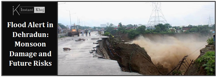
Cloudburst & Heavy Rainfall: On the night of September 15‑16, 2025, Dehradun saw a cloudburst near Sahastradhara and other hilly parts.
-
The downpour caused rapid swelling of rivers and streams, especially the Tamsa River, which overflew its banks and flooded religious sites like the Tapkeshwar Mahadev Temple.
-
Waterlogging was severe in low‑lying and residential areas; roads, shops and restaurants near riverbeds and streams got badly affected.
-
Two people went missing as homes, roads, and shops were washed away in certain zones. Rescue operations were activated by SDRF, police, and other emergency agencies.
Impacts: What Has Been Damaged or Disrupted
Type of Impact | Details |
|---|---|
| Infrastructure & Property | Flooding of roads, shops, restaurants, damage in commercial areas near water bodies. The Tapkeshwar Mahadev temple premises were inundated; some buildings suffered water damage. |
| Transport & Connectivity | Some roads have been blocked or made impassable due to waterlogging, landslides, and debris. |
| Religious & Cultural Sites | Tapkeshwar Mahadev Temple, a popular worship site, was flooded in the courtyard and surrounding areas (though the inner sanctum was reportedly okay). |
| Human Safety & Casualties | Two people missing; rescue efforts underway. Some evacuations in vulnerable areas. |
| Daily Life | Schools and Anganwadis (pre‑school centres) closed. Disruptions in traffic. Homes in low‑lying areas saw water entering living spaces. |
Response & Action by Authorities
-
Alerts Issued: Red alerts / orange alerts for heavy rain, flooding, landslide risk in many areas of Dehradun.
-
School Closures: From Class 1 to 12, and Anganwadi centres, closed to keep children safe.
-
Rescue Operations: SDRF, police, district administration are mobilized. Efforts include evacuations, search for missing persons, clearing debris, restoring connectivity.
-
Monitoring: Chief Minister, District Magistrates have reviewed the situation. Authorities are inspecting damage and coordinating relief.
Key Areas at Risk / Vulnerable Zones
-
Sahastradhara region (cloudburst and hill slopes)
-
Areas along Tamsa River and Tapkeshwar Temple surroundings
-
Low‑lying residential localities: GMS Road, Majra, Dalanwala, Dharampur, Selaqui, Chandrabani, Doiwala etc., which suffer drainage issues.
-
Flood‑prone roads and those near riverbanks or with weak slope stability. Landslide‑prone zones in hills and near unstable slopes.
Causes: Why the Flooding is So Severe
-
Extreme Rainfall & Cloudbursts: Sudden very heavy rains in short time cause rivers & streams to rise quickly. Hillsides get saturated, triggering landslides.
-
Topography: Dehradun lies in the Doon Valley, surrounded by hills. Streams and rivers coming down from the hills collect and can overflow. Plus, steep slopes are prone to landslides.
-
Poor Drainage & Urban Planning: Drainage channels are often choked, encroachments block natural drains, water has less place to go. Waterlogging is worse in areas with inadequate infrastructure.
-
Land Use & Deforestation (implied): Hillsides without enough vegetation retain less water; loose soil more easily erodes or slides. While not always explicitly stated in recent reports, these are recurring factors in Uttarakhand flood disasters.
What’s Being Done / What Needs to Be Done
-
Immediate Relief & Rescue: Evacuating people, searching for missing, medical assistance, temporary shelter, restoring connectivity.
-
Infrastructure Repair: Clearing blocked roads, drains; reinforcing vulnerable slopes; repairing damage to public works (roads, bridges).
-
Alert Systems & Weather Forecasting: Real‑time alerts from IMD, deployment of disaster response forces in advance when rain forecast is heavy.
-
Community Awareness: Advisories to avoid riverbanks, stay indoors during heavy rain, avoid travel in vulnerable zones.
Risks Still Present & What Residents Should Be Aware Of
-
Sudden cloudburst can happen with little warning; risk of flash floods.
-
Landslides in hilly edges, especially where slope stability is compromised by construction or deforestation.
-
Waterlogging in low areas can lead to flooding of homes, contamination of drinking water, health hazards.
-
Disruption to power, communication, roads. Isolation of remote areas.
-
Cultural/religious sites in flood plains remain at risk (like Tapkeshwar Temple).
Final Thoughts
The floods and cloudbursts in Dehradun district are yet another reminder of how monsoon season in hill‑states like Uttarakhand demands respect and readiness. The combination of geography, intense rainfall, and infrastructural vulnerabilities make flooding a recurring threat. While authorities are mobilizing fast and taking preventive measures, long‑term planning (better drainage, slope management, development control, land conservation) will be critical.
For locals, staying updated with weather alerts, following official instructions, avoiding risky areas, and helping community efforts (if possible) can make a big difference in safety.